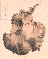
 Radarkarte des Kontinents Antarktika
© Ken Jezek => Zurück zum Artikel
Radarkarte des Kontinents Antarktika
© Ken Jezek => Zurück zum Artikel
Antarktika
Bildinfo und Lizenz
Bildinfo
- Radarkarte des Kontinents Antarktika
- Shaded relief map of Antarctica developed from RADARSAT Synthetic Aperture Radardata.
- RADARSAT is a Canadian satellite.
Source
- Date: Not later than the year 2019
- Author: Ken Jezek
- Credit: NOAA, Ohio State University
License
Images in the NOAA Photo Library are in the public domain and cannot be copyrighted. There is no fee for downloading any images on the site. Educational use is encouraged as the primary goal of the NOAA Photo Library is to help all understand our oceans and atmosphere.
Originalseite
- Das Bild ist Teil eines online-Lexikons.
- Rhetos Lernlexikon Mathematik, Aachen:
- Siehe unter => Antarktika