 Oben:
© Gunter Heim => Zurück zum Artikel
Oben:
© Gunter Heim => Zurück zum Artikel
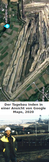
Tagebau Inden
Bildinfo und Lizenz
Bildinfo
- Man sieht eine Luftaufnahme von Google Maps, 2020
- Man sieht den Autor vor dem damaligen Bandsammelpunkt.
- Die Aufnahme entstand im Winter 1996.
Source
- Ansicht aus Google Maps, 2020
- Created: February 3rd, 2019
License
- Subject to your compliance with this Agreement's terms, Google grants you a non-exclusive, non-transferable license to use Google Maps/Google Earth, including features that allow you to: view and annotate maps; create KML files and map layers; publicly display Content with proper attribution online, in video, and in print ... Quelle: https://www.google.com/intl/en-US/help/terms_maps/ [28. März 2020]
- This image is not in the Public Domain.
- No usage without a written consent by the author.
Warranty
- No guarantee can be given as to the correctness of facts implied or explicitly stated.
- Usage is completey at your own risk. 💣
Originalseite
- Das Bild ist Teil eines online-Lexikons.
- Rhetos Lernlexikon Mathematik, Aachen: