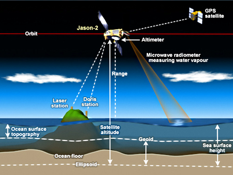
 Ein Satellit vermisst die Höhe der Erdoberfläche: die Höhe ist eine typisch messbare Eigenschaft.
© NOAA Satellites => Zurück zum Artikel
Ein Satellit vermisst die Höhe der Erdoberfläche: die Höhe ist eine typisch messbare Eigenschaft.
© NOAA Satellites => Zurück zum Artikel
Messbare Eigenschaften der Welt
Bildinfo und Lizenz
Bildinfo
- Ein Satellit vermisst die Höhe der Erdoberfläche: die Höhe ist eine typisch messbare Eigenschaft.
- Originalbeschriftung: How satellite radar altimetry works. Satellite radar altimeters measure the ocean surface height (sea level) by measuring the time it takes a radar pulse to make a round-trip from the satellite to the sea surface and back. This diagram shows how the Jason satellite series measure ocean surface height and how that is used to estimate the topography of the ocean floor.
Source
- Source: hhttps://commons.wikimedia.org/wiki/File:How_satellite_radar_altimetry_works_(16980176380).jpg
- Created: April 16th, 2015
- Author: NOAA Satellites
- Credit: NOAA
License
Images in the NOAA Photo Library are in the public domain and cannot be copyrighted. There is no fee for downloading any images on the site. Educational use is encouraged as the primary goal of the NOAA Photo Library is to help all understand our oceans and atmosphere.
Warranty
- No guarantee can be given as to the correctness of facts implied or explicitly stated.
- Usage is completey at your own risk. 💣
Originalseite
- Das Bild ist Teil eines online-Lexikons.
- Rhetos Lernlexikon Mathematik, Aachen:
- Siehe unter => messbare Eigenschaften der Welt => lex