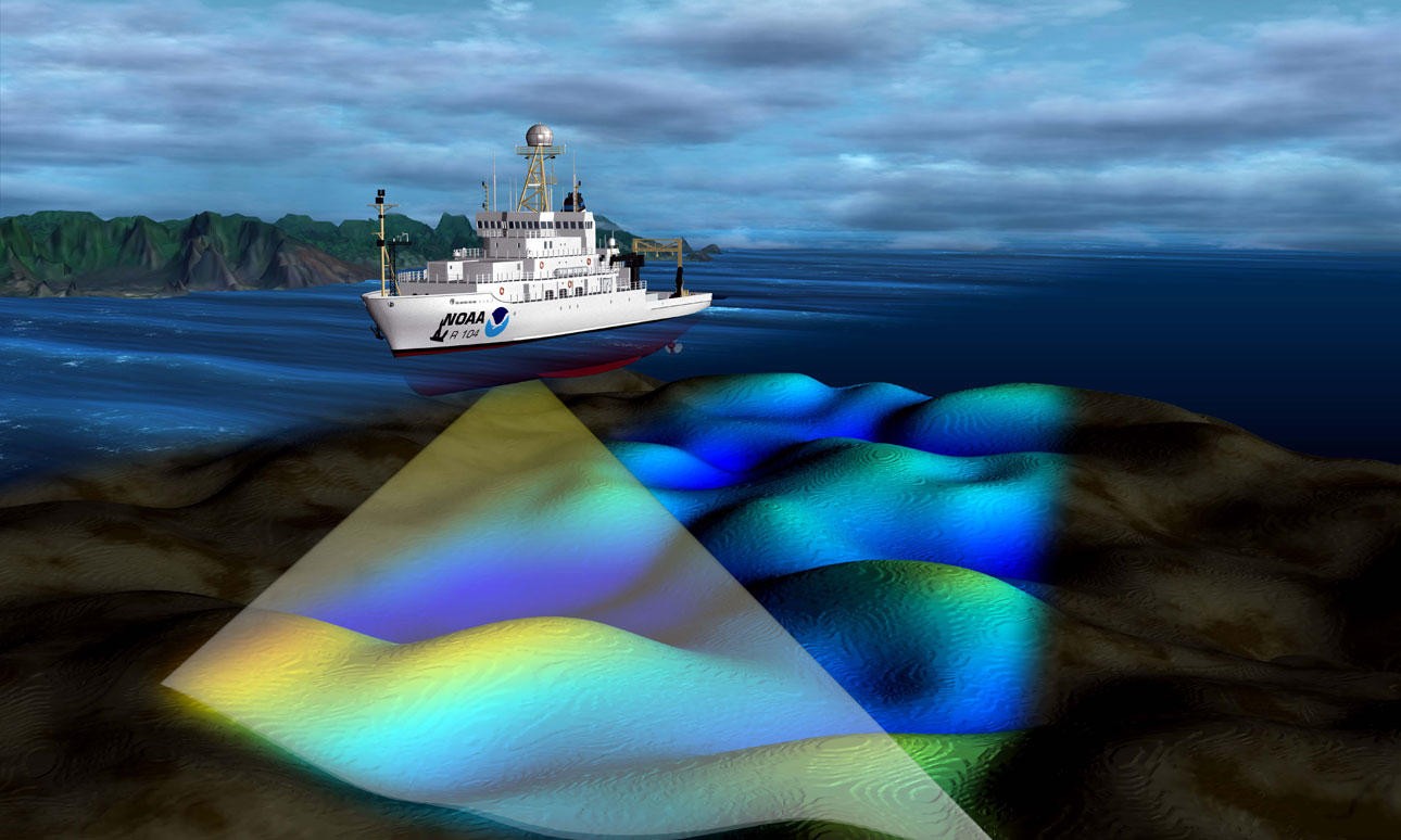
 Schall von einem Schiff wird am Meeresboden reflektiert. Die Dauer zwischen der Aussendung und dem Empfang am Schiff lässt Rückschlüsse auf die Tiefe des Meeresbodens zu. Moderne Systeme können daraus 3D-Karten des Meeresbodens erzeugen. Ein Anwendungsgebiet ist die Aktualisierung von Seekarten, z. B. in Gebieten mit häufig wechselnden Sandbänken.
© NOAA's National Ocean Service => Zurück zum Artikel
Schall von einem Schiff wird am Meeresboden reflektiert. Die Dauer zwischen der Aussendung und dem Empfang am Schiff lässt Rückschlüsse auf die Tiefe des Meeresbodens zu. Moderne Systeme können daraus 3D-Karten des Meeresbodens erzeugen. Ein Anwendungsgebiet ist die Aktualisierung von Seekarten, z. B. in Gebieten mit häufig wechselnden Sandbänken.
© NOAA's National Ocean Service => Zurück zum Artikel
Echolot
Bildinfo und Lizenz
Bildinfo
- Schall von einem Schiff wird am Meeresboden reflektiert. Die Dauer zwischen der Aussendung und dem Empfang am Schiff lässt Rückschlüsse auf die Tiefe des Meeresbodens zu. Moderne Systeme können daraus 3D-Karten des Meeresbodens erzeugen. Ein Anwendungsgebiet ist die Aktualisierung von Seekarten, z. B. in Gebieten mit häufig wechselnden Sandbänken.
- Multibeam sonar systems emit sound waves from directly beneath a ship's hull to produce fan-shaped coverage of the sea floor. These systems measure and record the time elapsed between the emission of the signal from the transducers to the sea floor or object and back again. Multibeam sonars produce a 'swath' of soundings (i.e., depths) to ensure full coverage of an area. Hydrographic data collected from these sonar systems are used to update nautical charts.
Source
- Created: December 7th, 2009
- Author: NOAA's National Ocean Service
- Credit: NOAA
License
Images in the NOAA Photo Library are in the public domain and cannot be copyrighted. There is no fee for downloading any images on the site. Educational use is encouraged as the primary goal of the NOAA Photo Library is to help all understand our oceans and atmosphere.
Warranty
- No guarantee can be given as to the correctness of facts implied or explicitly stated.
- Usage is completey at your own risk. 💣
Originalseite
- Das Bild ist Teil eines online-Lexikons.
- Rhetos Lernlexikon Mathematik, Aachen:
- Siehe unter => Echolot
