 Man sieht Containerbrücken (Kräne) als Luftaufnahme.
© Google Maps => Zurück zum Artikel
Man sieht Containerbrücken (Kräne) als Luftaufnahme.
© Google Maps => Zurück zum Artikel
Projektion
Bildinfo und Lizenz
Bildinfo
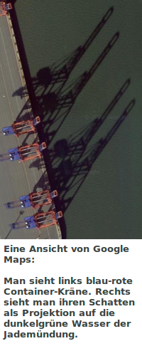
- Man sieht Containerbrücken (Kräne) als Luftaufnahme.
- Man sieht ihren Schatten auf dem Wasser der Jademündung.
Source
- Created: Unknown date, building phase of JadeWeserPort
Licence
- Auszug des originalen Google-Lizenz-Textes vom 28. März 2020: "Subject to your compliance with this Agreement's terms, Google grants you a non-exclusive, non-transferable license to use Google Maps/Google Earth, including features that allow you to: view and annotate maps; create KML files and map layers; publicly display Content with proper attribution online, in video, and in print ... "
Warranty
- No guarantee can be given as to the correctness of facts implied or explicitly stated.
- Usage is completey at your own risk. 💣
Originalseite
- Das Bild ist Teil eines online-Lexikons.
- Rhetos Lernlexikon Mathematik, Aachen: